 |
||||||||
Ecosystem Resource Planning Extends Offshore
By Matthew Cimitile and Allie Wilkinson
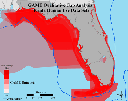
Image courtesy National Oceanic and Atmospheric Administration
Some local agencies, including Florida Fish and Wildlife Conservation Commission, already have begun cataloging natural resources and human use.
The nation’s first-ever ocean stewardship policy promises to “strengthen ocean governance and coordination” by using a strategy most often executed by land-use planners. Called coastal and marine spatial planning, it brings together local stakeholders to determine where it is most appropriate to allow certain types of activities.
“Coastal and marine spatial planning is a way to help organize the different activities that people have in the ocean and coastal zones so that they do not interfere with each other,” said Frank Muller-Karger, biological oceanographer at the University of South Florida’s College of Marine Science. “It requires careful analyses of what activities are going on and also what activities may be planned in the future so that the resource is protected for the long-term.”
Perhaps the best way to understand coastal and marine spatial planning and the benefits it could provide is to look at what it is not, according to the President’s Ocean Policy Task Force. First, it is not just creating a map, a zoning plan or establishing restrictions on activities; rather, this type of planning seeks a balance between environmental conservation and economic development. Secondly, it is not a plan set in stone. As knowledge and information about the environment change, so too will the management plans that address those varying circumstances. Finally, it is not ocean zoning. Zoning of the ocean has taken place for years, providing specific lanes for ocean transportation or giving rights in an area to explore energy production.
But that has been, and is done today, on a single-sector basis. Though coastal areas are used for various purposes – such as commercial and recreational fishing, maritime commerce, or even set aside as marine reserves for conservation and research — they most often have been planned and situated without taking into account other users of that resource or appropriate sustainable use.
“Historically and even now, we manage in this country by a single sector authority that is usually a single program within a single agency,” said Charles Wahle, senior scientist at NOAA’s National Ocean Service. “Within this single-sector authority are statutes that govern a particular use or a particular species, but they are not necessarily structured in a way that takes other uses into account.”
For instance, consider a coastal area where one stakeholder wants to place an offshore aquaculture farm while another wants to expand a port to allow greater amounts of cargo shipping. The two activities are not necessarily compatible. With no prior discussions between stakeholders and regulators, you either get parties competing for the same space or direct conflicts where one use makes the other impossible, said Wahle.
The permitting and regulatory environment makes it even more complicated. According to a 2009 Joint Ocean Commission Initiative report, oceans are managed under more than 140 different federal laws and by 18 federal agencies. As one report in Science magazine notes, it’s like having “a number of specialist physicians, who are not communicating well, treating a patient with multiple medical problems.”
So far, the result is a rapid deterioration in the patient’s health.
“People who live and work along the coast or on the ocean are witnessing the dramatic decline of our marine resources due to natural and anthropogenic disturbances,” said Cristina Carollo, research associate at the Florida Institute of Oceanography. “Fisheries are in decline, pollution is increasing and oil spills are causing major issues to marine life. This is the result of sector-by-sector management practices that have been carried out for, at least, the last 30 years.”
For instance, nearly half the American population resides within 50 miles of a coast. At the same time, a “dead zone” of oxygen-depleted waters about the size of New Jersey forms each year at the mouth of the Mississippi River fueled by nutrient-laden runoff from farms and urban areas along the river’s course. New alternative energy sources, such as wind farms and generators that harness tidal power, are being considered and developed. And that’s before including the ongoing impacts of offshore oil wells, symbolized by the Deepwater Horizon spill, that pose significant risks to wetlands, wildlife, beaches and local economies.
Replacing the single-sector approach with a more holistic planning style that takes into account all activities and gives a voice to all concerned is a critical first step in the new oceans stewardship policy. This policy calls for nine regional groups to develop comprehensive coastal and marine spatial plans for their regions within the next five years. Once in place, planning processes will probably follow a format like that laid out in a 2009 Intergovernmental Oceanographic Commission publication:
- Identifying needs and establishing authority
- Organizing pre-planning and stakeholder participation
- Defining and analyzing existing and future conditions
- Preparing and approving the spatial management plan
- Implementing, enforcing, monitoring and evaluating the plan
- Adapting the marine spatial management process
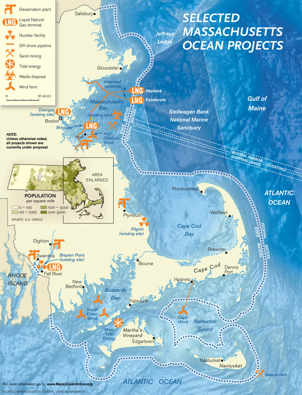
Click image to zoom.
Courtesy of Massachusetts Coastal Zone Management
This coastal planning map for Massachusetts designates areas where wind farms, nuclear facilities and desalination plants could be incorporated along with the already-established shipping lanes and marine sanctuaries.
Policy makers and scientists foresee the policy creating safe and productive oceans, coasts and Great Lakes; providing and maintaining public access; and promoting compatibility among uses. This in return will help maintain native species diversity, habitat diversity and populations of key species while clarifying which agencies oversee permitting for marine development and thus streamlining permitting and regulatory processes.
“In the end, decisions will match uses to places in the ocean where those uses can be sustained, where the impacts are minimal and the benefits maximum,” said Wahle. “If we do it right, we will have a system where necessary and value uses are accommodated and where ecologically sensitive places are maintained.”
Perhaps no area would benefit more from this new management approach than Florida – and in particular Tampa Bay. Numerous coastal and marine ecosystems along the state’s 1,197 miles of coastline need to coexist with an economy driven by tourism and industry. Balancing between people flocking to healthy, clean beaches, a fishing industry dependent on sustainable resources, and associated flourishing ecosystems in protected marine areas will be critical to maintaining both ecosystems and economies.
Data has been developed on both a national and local basis. NOAA’s Multipurpose Marine Cadastre (MMC) details the jurisdictional boundaries, restricted areas, laws, critical habitat locations, and other important features for much of the nation’s coastal areas. Locally, several technologies are already in place to aid in coastal and marine spatial planning including the Manatee Awareness & Protection Resource and the Florida Regional Marine Mapping and the Geospatial Assessment of Marine Ecosystems (GAME).
These locally created and maintained tools are critical in mapping and cataloging existing coastal, nearshore and offshore features. For example, GAME assembles existing data sets and information to assess marine habitats and structure while also identifying information gaps. Maps are then produced from the assembled data sets that will allow resource managers access to critical information on ecosystem structure and function to support their decisions.
“This planning has already been done on land for decades,” Carollo said. “So why not in Tampa Bay? There are planning departments in every city, county, and state that create land-use maps to inform development decisions to minimize user conflicts. We must do the same in the bay to maintain a healthy ecosystem.”
At the current level of growth, it’s likely that greater conflicts between uses will occur over limited resources as vital ecosystems degrade. To avoid this scenario, critical planning of all activities is needed that takes into account ever-changing information and understanding of the resources. Through updated data, stakeholder input and a flexible adaptive management environment, best matches can be made to sustain the healthy functions of ecosystems and dependent societies on the coast.
Matthew Cimitile is a regular contributor to Bay Soundings. He currently works as a journalist/multimedia specialist at the U.S. Geological Survey St. Petersburg Coastal and Marine Science Center in St. Petersburg, Fl. He can be reached at mcimitile@usgs.gov. Allie Wilkinson spent the summer of 2010 as a science communications intern at the USGS.