|
||||||
|
||||||

Gulfstream Proposes Underwater Pipeline To Weedon Island
In the first major expansion since its completion in 2002, Gulfstream Natural Gas System hopes to build a 17.5-mile pipeline to serve Progress Energy’s power plant on Weedon Island. Switching the plant to natural gas is expected to reduce emissions of sulfur dioxide, nitrogen oxides and particulates by more than 90% even as generating capacity doubles.
Plans for the underwater pipeline, which would extend north through Tampa Bay from near Port Manatee, are being drafted now, with a special emphasis on avoiding or minimizing impacts to live bottom habitat and seagrass. Researchers surveyed a 1,000 foot-wide corridor in Tampa Bay earlier this year looking for hard bottoms, submerged aquatic vegetation, archeological points of interest and potential construction hazards using magnetometer, side scan sonar, sub-bottom profiler and echo sounder technology.
Parts of the pipeline will be constructed using horizontal directional drilling that allows Gulfstream to avoid sensitive environmental areas and cross channels by burying the pipe at depths greater than could be achieved with traditional trenching. Other sections will be built using shallow-water pipe-lay barge capable of laying approximately 4,000 feet of pipe per day with each 40-foot section of concrete-coated pipe weighing about 15 tons.
To learn more, visit www.gulfstreamgas.com/phase4.
Red Tide Updates Online
After nearly 11 months without a red tide outbreak on the Gulf coast, low levels of Karenia brevis, the organism responsible for Florida's red tides, were seen at several sites off Lee and Pinellas counties in late June.
It's important to note that Karenia brevis cells are always present in the Gulf of Mexico and that low concentrations recorded in a few water samples in disparate places do not necessarily indicate a larger red tide bloom.
The Florida Fish and Wildlife Research Institute updates its website with the most recent information available every Tuesday and Friday. For more information visit www.floridamarine.org and follow the link to ‘Red Tide Current Status.’ Information also is available by phone at 866-300-9399.
Time for A Reality Check
With the Tampa Bay region expected to welcome 1.2 million new residents between 2000 and 2015, and an estimated population of 5 million residents by 2025, where will people live? Where will they work? And how will the region manage the new growth while retaining the quality of life that attracted so many in the first place?
The Urban Land Institute Tampa Bay and the Tampa Bay Partnership have joined together with the Southwest Florida Water Management District, Tampa Bay Regional Planning Council and the Tampa Bay Estuary Program to stage Reality Check Tampa Bay. The one-day exercise is designed to analyze and develop alternative growth scenarios for our rapidly growing region through 2025. Nearly 300 political, business, environmental, real estate and civic leaders will be invited to attend the participatory event planned for next May. The Tampa Bay region will be the 5th area nationwide to stage the interactive ULI program.
For more information, contact Reality Check program manager B. Terry Johnson, Associate in Research at USF's Florida Center for Community Design and Research, at (813) 974-1506 or email BTJohnson@arch.usf.edu.
Vessel Location Service Available on Gulf Coast
Using hardware most boaters already own and “connecting the dots,” a new service now offers real time vessel location and tracking on Florida’s Gulf coast from any web-enabled device. Available here since February with plans to roll out across the country by later next year, the new program is available through Sea Tow Services, the nation’s largest marine assistance company.
“Since 1998, every marine radio has had to be compatible with GPS service, so if you enable the radio and key the mike, we know who and where you are,” says Joshua Y. Horton, spokesman. “It also includes unlimited direct-to-shore calls, which can be important since cell phone service is spotty once you’re offshore.”
Sea Smart subscribers receive a unique MMSI number that allows their boat’s location to be monitored from web-enabled devices – either on a home computer or a Sea Smart operator’s screen. Should a subscriber need assistance, Sea Smart’s operators can easily communicate with the boater, establish his exact location and immediately dispatch the nearest Sea Tow provider or U.S. Coast Guard unit.
The annual subscription is $11.95 per month for Sea Tow members or $16.95 monthly for non-members. For more information, visit www.seasmartvhf.com.
World’s First Commercial Wave Power Plant Online in Scotland
Solar, wind – and now wave – power are helping the world escape its dependence on petroleum. A new plant in Scotland produces about 500 kilowatts of energy – enough to power about 300 homes – by harnessing the energy in waves as they crash ashore.
Officials at Wavegen, the British company that built the plant, told the BBC that there could be enough wave power around the British Isles to generate more power than current domestic demands. Other experts say that less than 0.1% of the renewable energy within the world's oceans could supply more than five times the global demand for energy - if it could be economically harvested.
The plant in Scotland is designed with a partially submerged chamber that collects and releases ocean water. Incoming and receding waves displace air in the chamber, forcing it in and out of specially designed turbines, which drive generators that produce electricity.
If this project succeeds, Wavegen hopes to build larger stations that operate more cost-efficiently. Current costs are about 9 cents for kilowatt hour, slightly more expensive than wind power but about three times the cost of power produced with coal or gas.
NOAA Asks For Help Protecting Wild Dolphins
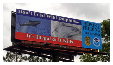 An eye-catching billboard in Charlotte County telling people that feeding wild dolphins is illegal and potentially lethal to the animal marks a new outreach tactic for NOAA Fisheries Service.
Studies have shown that feeding wild dolphins places them at greater risk of injury from boats or ingestion of inappropriate food items, such as fishing hooks and contaminated food. Feeding wild dolphins can also affect their ability or willingness to forage for food on their own, making them more dependent on people for handouts and potentially passing those traits on to their calves and other dolphins. Additionally, dolphins who learn to identify boats with food can interfere with other boaters, creating dangers for the dolphins and diminishing the fishing experience for the anglers.
Other studies, including long-running research at Mote Marine Laboratory, demonstrated that increased public awareness can decrease dolphin feeding. “Unfortunately, all it takes to perpetuate the problem is for a few people to continue to feed dolphins,” notes Dr. Randall Wells, director of Mote’s Center for Marine Mammal and Sea Turtle Research. “Hopefully, the new billboard will get the message through more clearly to those who continue to feed these wild animals.”
Watching wild dolphin is encouraged, but NOAA officials ask that people stay at least 50 yards away.
Drug Discovery Team Explores Deep-Sea Reef
A reef discovered last year deep in the Florida Straits may hold more treasure than a sunken galleon if researchers can identify new chemical compounds with the potential to treat human diseases such as cancer and Alzheimer's.
"We've found incredible and surprising diversity at other deepwater reefs near Miami and Bimini, and some promising potential disease treatments, so we're very excited about the chance to explore these new areas," says Amy Wright, director of the Harbor Branch Division of Biomedical Marine Research.
For decades, researchers have suspected that deep reefs lay undiscovered between Miami and Bimini because pieces of reef-building corals had been brought up. However, the location was unknown until last year when University of Miami researchers, funded partially through the National Oceanic and Atmospheric Administration’s Ocean Exploration program, began mapping deepwater habitats with an autonomous underwater vehicle (AUV) equipped with advanced sonar technology.
The research revealed what appears to be an extensive system of steep slopes and mounds as high as 350 feet, all of which are likely to harbor a wide array of sponges, corals, fish and other animals. Using a submersible, Harbor Branch researchers collected organisms that will be tested to determine if they, or microorganisms living within them, produce chemicals with pharmaceutical potential.
Lake Seminole Restoration Earns Back-to-Back Awards
 Ongoing restoration efforts at Lake Seminole are earning accolades with a first-place award for landscaping from the Florida Native Plant Society following on the heels of the recent first-place finish in the Tampa Bay Regional Planning Council Future of the Region’s environmental category.
Once estuarine tidal flats, Lake Seminole was created in the 1940s by closing in a portion of Long Bayou. The award-winning shoreline restoration includes littoral shelf enhancement on the shores of a 3.7-acre pond, creation of a wildlife island, installation of an aeration system, and planting of native vegetation along the shoreline.
The pond restoration is part of a multi-year initiative that also includes new stormwater treatment systems and lowering the lake’s water level to remove nutrient-laden sediments at the bottom.
New Policies Recognize Priorities At National Wildlife Refuges
New policies that recognize the challenges faced at National Wildlife Refuges have been formalized to encourage refuge managers to provide additional recreational opportunities while also establishing clear guidelines to ensure that recreational programs are compatible with the refuge’s conservation mission.
“These policies will ensure that we meet our conservation goals while offering more opportunities for families to enjoy wildlife-dependent recreation," noted U.S. Fish and Wildlife Service Director H. Dale Hall.
The policies, available online at www.fws.gov, focus first on the wildlife protection and conservation, but also recognize the increasing demand for recreational opportunities.
In the Tampa Bay region, refuges include Egmont Key, Chassahowitzka, and Crystal River, all open to the public with opportunities for passive recreation. Passage Key and the Pinellas National Wildlife refuges are critical habitat for nesting birds and are not open to the public. For more information, visit http://www.fcnwr.org.
Website Maps “State of the World”
The Global Education Project’s new website at www.theglobaleducationproject.org offers a graphic view of the world with a series of maps that detail the condition of the world's environment - both natural and human -- in a format design to show how they interact and affect each other.
While the site presents a world view rather than focusing on any specific region, the maps and graphs cover a wide range of issues including fresh water supplies and uses, wealth distribution and climate change, oil supply and food production, global forests and global fisheries, toxics and soil degradation, population and bio-diversity. Data is fully footnoted.
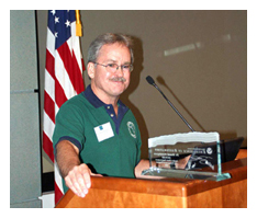
NOAA Recognizes District Scientist for Excellence
The National Oceanic and Atmospheric Administration (NOAA) has honored Dr. Brandt Henningsen, a senior environmental scientist with the Southwest Florida Water Management District, with its Excellence in Restoration Award. Henningsen received the award in May at a meeting of conservation partners sponsored by the Pinellas County Environmental Fund.
 Henningsen has directed 33 of 65 projects for the District’s Surface Water Improvement and Management (SWIM) program, resulting in the restoration of more than 830 acres of bay habitat. His handiwork encompasses a string of coastal restoration projects along Tampa Bay’s southeastern shoreline, including Schultz Preserve, E. G. Simmons Park, Cockroach Bay Preserve and work now underway at the 2000-acre Terra Ceia Preserve, the largest habitat restoration project ever conducted within the estuary.
Terra Ceia and the planned restoration of the 1000-acre Rock Pond parcel just north of Port Manatee, “are the last grand hurrahs for Tampa Bay as far as large ecosystem restorations go,” says Henningsen, who has been with SWIM since 1987. They are the final links in a nearly unbroken chain of coastal conservation habitat stretching from the Alafia River down to the Manatee River.