From the icy waters of the Arctic Ocean to the Gulf of Mexico and Tampa Bay, cutting-edge research by Ocean Team scientists is gaining international acclaim.
In the days and months following one of the nation’s worst environmental disasters, scientists from the University of South Florida made national headlines for their response and ongoing analysis of the April 2010 BP Deepwater Horizon oil spill.
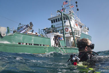
From the first day of the blowout, scientists from USF’s College of Marine Science were involved in tracking the spill, collecting water and oil samples and predicting where and how quickly the oil was moving, and later analyzing the spill’s environmental impact.
As if images of birds, fish and animals killed by floating oil in the Gulf of Mexico weren’t disturbing enough, USF scientists discovered another danger lurking underwater – deepwater oil plumes, some 600 feet thick reaching depths of more than 3,900 feet. While BP initially denied their existence, a team led by USF Chemical Oceanographer David Hollander ultimately traced the plume’s oil to the blown-out well head using molecular isotopic fingerprinting.
BP initially said that about 1,000 barrels of oil per day were leaking into the Gulf of Mexico. Using satellite data, Florida State University Professor Ian McDonald challenged those figures, estimating that the oil gushing out was more on the order of 26,500 barrels. Live video feeds – released only after scientists turned to the media who in turn put pressure on politicians, the Obama administration and BP – ultimately revealed the massive scale of the blowout: about 50,000 barrels of oil were being released into the gulf each day, even more than Florida scientists feared.
In 2011, the College of Marine Science received an $11-million grant from BP’s Gulf of Mexico Research Initiative to lead an international consortium that continues to study the effects of the oil spill, including impacts to marine life. A gulf-wide survey led by USF that summer found more sick fish in the area of the oil spill than anywhere else. While USF scientists can’t conclusively trace lesions discovered on red snapper and other fish to the BP spill, emerging laboratory studies show that chronic exposure to oil causes everything from genetic defects to compromised immune systems.
Source: USF, WUSF Public Media, CNN.com, tampabay.com
Research on Top of the World and in Tampa Bay: USGS
From the icy waters of the Arctic Ocean to Florida’s largest open-water estuary, Tampa Bay, local scientists from the U.S. Geological Survey (USGS) are conducting pioneering research that is gaining international acclaim.
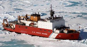
In 2010, researchers from St. Petersburg boarded the U.S. Coast Guard Cutter Healy to sample the remote waters of the Artic Ocean, piggybacking on a larger month-long USGS expedition to map the Arctic seafloor. The team of specialists included USGS senior scientists Lisa Robbins and Kim Yates and USF College of Marine Science Professor Bob Byrne.
By collecting CO2 data and related water and chemical samples in the largely uncharted Arctic waters, the scientists helped fill important gaps of knowledge that will contribute to a better understanding of the impacts of CO2 on ocean chemistry, trends in ocean acidification, and implications for climate change. “Models suggest that the Arctic is already undersaturated with respect to carbonate minerals during part of the year,” said Lisa Robbins, USGS oceanographer. “Our data provides important baseline information about this region.”
Oceans absorb about one-third of the total carbon dioxide (CO2) emissions generated worldwide by fossil-fuel combustion. As the CO2 is absorbed, it forms carbonic acid and lowers the slightly alkaline (basic) pH of seawater. Lowered ocean pH alters the ability of many calcifying marine organisms – corals, oysters and crustaceans, for example – to form skeletons and shells. Carbon emissions are projected to have risen 2.6 percent for 2012 over the previous year to a record high 35.6 billion tons, according to an analysis from the Global Carbon Project. As the basic chemistry of the oceans change, scientists fear those increases may cause profound changes in marine food webs and global ecosystems.
That’s just one example of the research taking place at the federal agency’s Coastal and Marine Science Center in St. Petersburg, a bustling three-building complex with a staff of 82. Its establishment here in 1988 was a game-changer for the city’s emerging marine science complex.
“Winning the national competition for the expansion of USGS was the single largest thing that could have happened to us – and a lot of people were surprised,” said Peter Betzer, who heads the St. Petersburg Downtown Partnership. The competition pitted USF Bayboro against 24 universities including Columbia and a North Carolina triumvirate led by Duke.
The opportunity to work with local scientists, plus the long-term database already in place, was a key consideration when the USGS selected Tampa Bay for its pilot study, according to senior scientist Kim Yates (see baysoundings.com/fall02/monitoring.html).
The five-year Tampa Bay Study, which began in 2001 and included a team of more than 60 scientists, has been called the largest multi-disciplinary science project ever orchestrated by the USGS. It was the first time scientists from all four USGS disciplines – geological, biological, chemical and hydrological – formed a fully integrated team. “We worked with the Tampa Bay Estuary Program and other agencies to determine where the research gaps were and how we could help, particularly how we could learn more about the bay as a system rather than collecting little pieces of data.”
The Tampa Bay Study involved drawing up maps of the sea floor, charting habitats, identifying the sources and quality of groundwater seeping into the bay – even reconstructing the region’s ancient environment. Tampa Bay may have originally started life as a giant sinkhole that became a freshwater lake before the sea broke through. “If we know how it looked in the past, we can build models that use that information to validate what may happen in the future,” Yates said.
After decades of pollution, Tampa Bay has rebounded to reclaim its position as the economic and environmental centerpiece of the Tampa Bay region. Overall water clarity is as good as it was in 1950, and Tampa Bay has more seagrasses than at any time since then, thanks to efforts to improve water quality and wildlife habitats, pollution control measures, and a community-wide recognition of the economic importance of a healthy bay.
Maintaining these gains as the region grows, and addressing emerging challenges such as climate change and sea level rise, will require continued focus and vigilance.
Source: USGS Sound Waves, Bay Soundings Fall 2002 issue, Maddux Report
Tavros, the Tweeting Bull
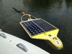
The newest member of the University of South Florida’s fleet of autonomous underwater vehicles, @Tavros02, is making quite a splash. For years, USF marine scientists have relied on bright yellow underwater vehicles to patrol the Gulf and report back findings on water conditions. @Tavros02 not only independently analyzes conditions in the water’s depths, it also uses Twitter to report back its findings. Outfitted with sensors and powered by solar cells, Tavros – Greek for bull, a nod to the USF Bulls – tweets raw data from the depths as it dives, relaying information on water temperature and pressure along with its coordinates. By pinpointing threshold levels from that data, Tavros can also tweet basic observations – confirming the presence of red tides or fishing conditions, for example.
The space-age social media hipster has a growing number of followers on Twitter and Facebook. Twitter followers can ask Tavros a question, and one of its human minions will actually tweet back using the Twitter handle @myhumansays. Developed by USF marine science engineer David Fries in collaboration with a team of engineers at the College of Marine Science, the concept for Tavros emerged in response to the Gulf oil spill. Had it been available then, Tavros not only could have mapped the oil but, before the event, also captured baseline conditions so scientists could track changes.
Sources: USF News and tbo.com.
[su_divider]Originally published Winter 2013