The Innovation Showcase is a new prestnation at the 2026 Resiliency Summit hosted by the Tampa Bay Regional Planning Council’s Regional Resiliency Coalition. The showcase will highlight cutting-edge solutions that are transforming how communities in the region approach resilience. Each participant will present a brief video overview of their technology in the main ballroom beginning at 11:30 am and then interactive Q+A sessions will be held until 1:30 pm. Local, state and national organizations including governments, universities, non-profits and businesses will be represented including:
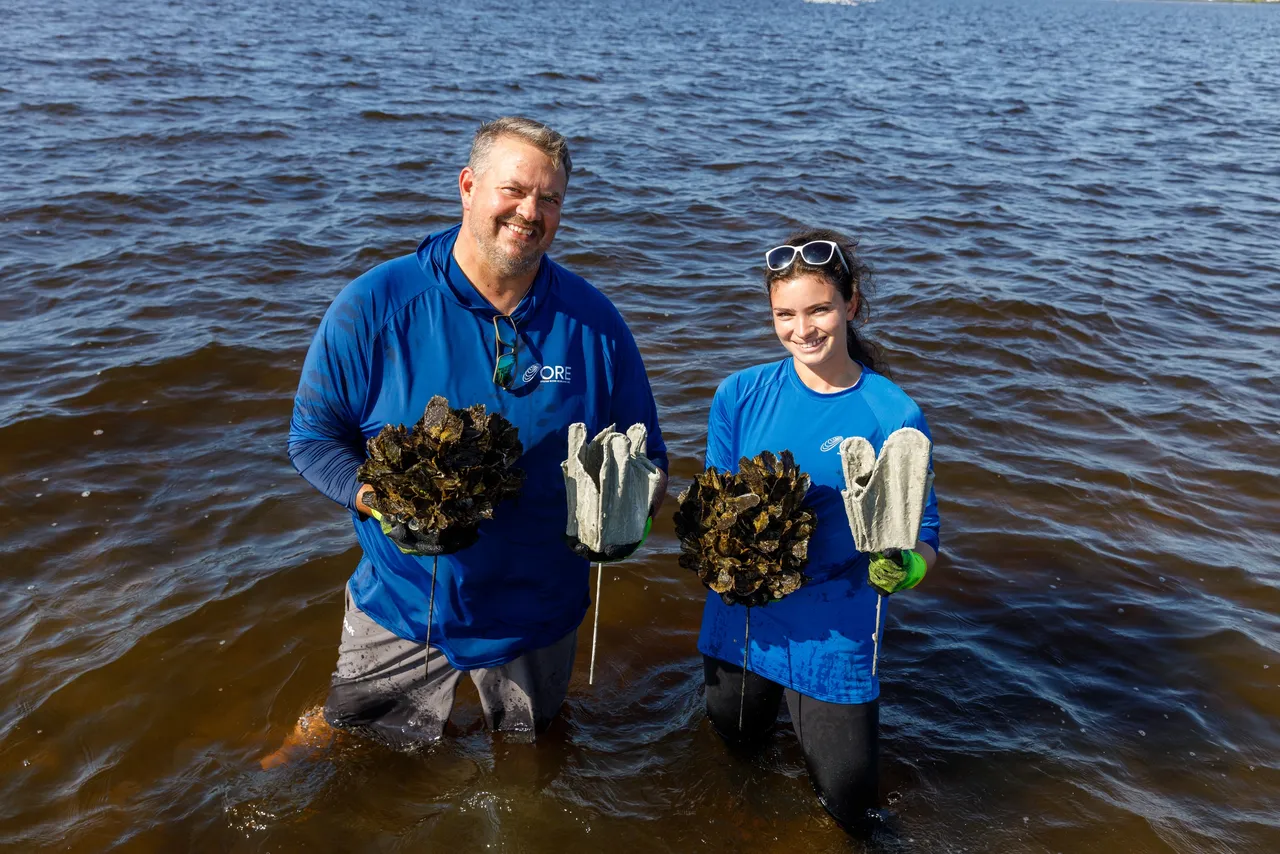
Oyster Rag Pots are an oyster restoration technique we developed to overcome the high cost of conducting large-scale oyster restoration. A sample of the ORPs installed last May show that an average of 101 oysters with an average size of 2.57 inches had naturally recruited to the innovative structure in about one year. So far, Oyster Restoration Ecology has installed about 35,000 ORPs in the Manatee Rover. (Professional video online at https://oysterriverecology.org/oyster-rag-pots.)
| Hohonu delivers hyperlocal coastal flood intelligence by combining low-cost water-level sensors, advanced data analytics, and AI-enhanced forecasting to help communities “stop guessing and start acting.” Built out of the University of Hawai‘i’s oceanographic research programs and strengthened through Elemental Excelerator’s climate-tech accelerator, Hohonu has grown organically into a trusted partner for emergency management, transportation, public works, and resilience offices across 18 states and more than 200 locations. Hohonu’s platform addresses a central challenge facing coastal communities: regional tide gauges and forecast products rarely capture the street-level variability that determines whether a neighborhood, evacuation route, or piece of infrastructure actually floods. Hohonu fills this gap by deploying dense networks of real-time water-level sensors paired with analytics, alerting tools, and machine-learning models that translate raw data into actionable, site-specific intelligence. Communities use Hohonu to monitor king tides, assess nuisance flooding, validate models, plan capital improvements, and ensure that emergency operations have accurate and timely situational awareness. Momentum in the Tampa Bay region continues to accelerate. Hohonu already partners with Lee, Pinellas, Pasco, and Charlotte Counties on a growing network of sensors supporting emergency management and public-facing flood dashboards. These deployments provide a strong regional foundation that can be leveraged for broader forecasting improvements and cross-county coordination during high-impact coastal events. By bringing research-grade sensing technology, AI-driven analytics, and a practical community-focused approach to coastal resilience, Hohonu aims to equip Tampa Bay communities with the tools needed to make faster, safer, and more informed decisions in the face of increasing coastal flooding. ( Manatee County’s innovative stormwater management system uses automated outfall structures (AOS) and continuous water quality monitoring to improve the flood protection and water quality treatment performance of pre-existing flood mitigation ponds located within flood-sensitive areas of Manatee County, such as the Pearce Drain/Gap Creek system. Our Public Works Department has been working on an SWFWMD operation permit for our first AOS site on Pearce Drain. The Natural Resources Department has installed continuous water quality monitoring probes in these systems to support operating patterns that provide enhanced water quality treatment by extending retention times when flood risk is minimal. Real-time water quality data and outfall controls are remotely managed by a telemetry system, which can then be interfaced to publicly accessible web pages. A professionally produced video will be available at the summit. Hernando County’s cloud-based permitting and workflow platform boosted efficiency by 93% and realized an estimated $1.5 million in savings after Hurricane Helene. In 2024, Hernando County, Florida, faced immense challenges following Hurricanes Helene and Milton, which caused record flooding, critical infrastructure damage, and overwhelming strain on its permitting and inspection operations. This disaster underscored the urgent need for a more resilient, efficient, and scalable system to support rapid community recovery and long-term disaster preparedness. To meet this critical need, Hernando County adopted SwiftGov in September 2024. This cloud-based permitting and workflow automation platform leverages AI to streamline processes, enhance transparency, and accelerate rebuilding efforts. This technology allows the county to process post-storm repair permits faster, reduce backlogs, and improve service continuity during a time of heightened community need. The County implemented SwiftGov AI under a policy of responsible technology adoption, ensuring technological efficiency is paired with professional oversight and local accountability. Although SwiftGov AI “streamlines routine checks and accelerates the review process,” full decision-making authority and final determinations remain with county staff, who retain complete control over enforcement and regulatory compliance, as detailed in the county’s innovation agreement. Since implementation, Hernando County has achieved a 93% increase in operational efficiency and realized an estimated $1.5 million in cost savings. As reports indicate, AI is cutting Florida building plan reviews from months to minutes. This success demonstrates how well-governed technology adoption can strengthen local government capacity, support faster disaster recovery, and build a more resilient foundation, offering a replicable framework for jurisdictions seeking to modernize operations while maintaining strong professional oversight. Save Crystal River’s innovative system for shoreline restoration is a proven system of environmentally friendly, aesthetically integrative shoreline resiliency restoration project designed to be implemented in Kings Bay. This process involves significant analysis of the wave patterns, and causes of degradation that are not only eroding the shoreline, but are also causing substantial sedimentation to fill the spring vents in the adjacent springs resulting in significant loss of spring flow. Two specific exoform units have been determined to be the most applicable to the Kings Bay System: the wave slope and the wave break systems. These are the two applications that Save Crystal River will be presenting during the Resiliency Summit. This exhibit will be featured on a 20’ trailer to demonstrate what these resiliency units will look like in an actual application. We will have biologists available to answer questions, along with a wave tank that demonstrates the effectiveness of seagrass and marsh grass for the protection of shorelines in instances of storm surges and wave action. AquaFence represents the forefront of deployable flood protection, offering a proven, engineered alternative to permanent infrastructure and archaic sandbag methods. Our patented FloodWall system is a reusable barrier that leverages the hydrostatic pressure of floodwaters to stabilize itself—the higher the water rises, the stronger the barrier becomes. Designed for rapid deployment, a small crew can install hundreds of linear feet in hours, protecting critical assets against flood levels up to nine feet. Crucially, the system is fully removable, preserving the aesthetic value, public access, and environmental integrity of the Tampa Bay coastline when not in use. This technology has already proven vital to the region’s resilience. AquaFence successfully protected Tampa General Hospital (TGH) during the record-breaking storm surges of Hurricanes Helene and Milton in 2024, ensuring the facility remained dry and operational when the community needed it most. Our systems hold the highest industry certifications, including FM Approval (ANSI/FM 2510) and compliance with ASCE 24-14 standards. We are innovating not just in hardware, but in application. Through our “Turnkey Subscription Model,” we are transforming flood mitigation from a capital-heavy construction project into a predictable operational utility—handling storage, deployment, and removal for our clients through local partnerships. At the showcase, we will demonstrate the system’s rapid assembly, highlighting its tool-free setup and robust engineering to show how Tampa Bay can adapt to rising seas. The Florida Digital Twin (FLDT) at the University of Florida is a computational platform that mirrors the shape, behavior, and interdependence of building sites, neighborhoods, transportation networks, and metropolitan regions facing environmental hazards. It integrates housing, mobility, employment, environmental quality, public health, and natural hazards data (historic, live, and future) into a unified framework that illustrates how urban systems function. The FLDT enables developers, architects, urban designers, and engineers to better assemble, model, compare, and visualize urban information to serve project-defined needs. By supporting professional design practice, the FLDT will catalyze action around hazard mitigation, planning, and design through web-based tools, specific software applications, and other customizable products. The Florida Digital Twin comprises a portfolio of easy-to-access AI models to simulate holistic urban environments (roads, trees, infrastructure, people, social data) against hazards to inform and shape resilient development projects and design solutions. It is delivered in an online web-based application for scenario testing and to demonstrate development projects interactively to stakeholders and the public. The FLDT also provides a state-wide database for baseline social, environmental, and infrastructure data and resources, available on the website. The multi-agentic AI architecture enables researchers, planners, and design practitioners to rapidly bring a range of multi-modal datasets into the FLDT and explore the platform’s functionality without GIS expertise. Users can interact with the interface using natural language, reducing barriers to geospatial analysis and modeling for smaller municipalities with limited resources and empowering residents with a greater ability to envision and take an active role in shaping the future of their communities. UrbanForest™ is an innovative modular soil cell system designed to promote healthy urban tree growth while supporting stormwater management. Its open skeletal matrix provides maximum root growth space, ensuring trees have access to soil, air, and water without compaction. This system integrates seamlessly into green infrastructure, reducing runoff, enhancing evapotranspiration, and improving nutrient uptake. UrbanForest™ helps cities combat common issues like damaged sidewalks and underdeveloped trees, while adding cooling, shade, and aesthetic value to urban landscapes. |