Written By Victoria Parsons
[su_tabs class=”my-custom-tabs”] [su_tab title=”Reality Check”]
[su_quote cite=”Stuart Rogel”]Just adding lanes or building new highways isn’t going to solve the problem. [/su_quote]
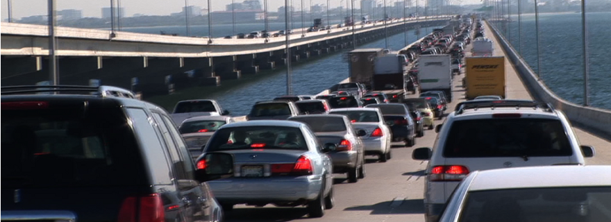
With purple ribbons for highways and orange bands for mass transit, participants in Reality Check easily identified the critical corridors needed to clear up Tampa Bay’s chronic congestion.
“People generally agree on transportation plans and links between corridors,” says Stuart Rogel, president of the Tampa Bay Partnership, the organization charged with economic development in a seven-county region stretching from Hernando to Sarasota and a sponsor of Reality Check, a one-day regional visioning exercise held in May. “It’s nearly intuitive.”
They also agreed that it would be impossible to build enough roads to keep seven million residents moving as the region’s population booms by 84% over the next 40 years, and made multi-modal transportation one of their top priorities. “Just adding lanes or building new highways isn’t going to solve the problem,” Rogel says. “Unless we have a strong transit system in place, Tampa Bay as a region is not going to continue to be competitive.”
But if the devil is in the details, then Tampa Bay’s traffic problems are on the wrong side of paradise. Questions like what to build first, where to put it and how to cover costs that will easily run into the billions of dollars are much more difficult to answer than connecting Lego blocks representing homes and employment centers with brightly colored ribbons.
Chicken and Egg
For the moment, Tampa Bay is in a chicken-and-egg situation. “The only way mass transit works well is with high density,” notes Manny Pumariega, executive director of the Tampa Bay Regional Planning Council, another sponsor of Reality Check.
Tampa Bay, built largely after World 2002War II when automobiles helped make a suburban ranch home on a large lot the American Dream for thousands of families, sprawls across much of the 4200 square miles the partnership encompasses.
While some areas of Tampa Bay are nearly dense enough, more density is needed for transit to be successful. And part of the challenge facing planners is overcoming the somewhat negative image of high density development and highlighting an appealing lifestyle with multiple amenities nearby. “Architects and designers need to do a better job blending high-density development and showing nearby residents how attractive it can be,” Pumariega said.
Approximately 2800 people per square mile live in Tampa Bay’s central business districts; that compares to 3000 in Atlanta, 3300 in Dallas and 3600 in Denver. “We don’t have that far to go,” he adds. “I think we’re in a prime position to develop a regional transit system.”
[su_box title=”Reality Check” box_color=”#4aa396″ radius=”2″]As much as some people would like to keep Tampa Bay just the way it is – or the way it was 40 years ago – limiting growth is not a viable option. Reality Check, a day-long regional visioning effort in May, was designed to help the region chart its future so the growth benefits current residents by increasing the community’s overall quality of life. Sponsored by the Tampa Bay Partnership, Urban Land Institute of Tampa Bay, Tampa Bay Regional Planning Council, Tampa Bay Estuary Program and the Southwest Florida Water Management District, Reality Check brought 300 representatives together to spend a day working with Legos and ribbons to design the Tampa Bay of the future. Tables of 10 residents drawn from all seven counties and all walks of life were charged with placing Legos on maps to represent the 3.2 million people and 1.5 million new jobs expected here by 2050. While each table predicted slightly different scenarios, the entire group then voted on six guiding principles that should direct development over the next 50 years. By number of votes, those principles include:- Promote quality communities to create a sense of place by uniquely clustering higher density mixed-use development organized around transportation corridors (29%)
- Maximize mobility using multi-modal transportation (24%)
- Preserve natural systems, emphasizing connectivity and sustainable water supplies (20%)
- Balance jobs and housing for affordable quality of life (12%)
- Attract higher paying jobs – strengthen economic development (12%)
- Preserve farmland and sustain the role of agriculture (3%)
[/su_box]
[/su_tab] [su_tab title=”Regional Approach”]
Regional Authority to Focus on Transit
The first step in that initiative is the creation of a Tampa Bay Regional Transportation Authority with 15 representatives including elected officials, professional planners and business leaders. Established by the legislature earlier this year, the authority’s $1 million budget for startup funding was vetoed by the governor.
“The funding isn’t really that big a deal,” Rogel said. “The FDOT (Florida Department of Transportation) actually has been working on a regional transit needs assessment for quite some time and will continue with that work. Our focus as a regional transportation authority will be to work with them and move forward as a well-organized group representing the region.”
A proposal for transit is already on the table, released in early July by the Regional Transit Work Group comprised of elected officials and planning professionals from across the region. For the first time ever, local plans have come together on a regional map highlighted by a rail corridor running from downtown Tampa to downtown St. Petersburg with stops in Westshore/Tampa International Airport and St. Petersburg’s Gateway area. Over time, the group would like to see rail links developed north to Brooksville, south to Sarasota and east to Polk County with boat ferries from Apollo Beach to downtown Tampa and St. Petersburg and enhanced bus transit across the region.
While those plans will be considered as part of a final proposal by the transportation authority, they’ll probably happen toward the end of a strategic master plan rather than as its first initiative. “I don’t really know where we start,” Rogel said. “Building anything across the bay is probably going to be very expensive and I wouldn’t be surprised if the first project was something besides rail.”
“We need to position ourselves and our communities to take advantage of opportunities as they arise and maintain high levels of flexibility,” adds Bob Clifford, FDOT’s director of planning for the region. “We can’t be so rigid that we’re all tied into this corridor or nothing.”
All agree that the region must come together and “sing from the same page” to find the funding necessary for the new systems – and that the first effort must be successful. “Once we show that we can be successful with the first leg of mass transit, the other pieces will fall into place,” Pumariega said.
“The Whole Toolkit”
While discussions about priorities may occasionally become heated, everyone generally agrees that there is no single magic bullet that will move seven million people around the region efficiently and affordably. “The truth of the matter is that we’ll need the whole tool kit, adding highway capacity where we can, building transit to carry more people, working with Bay Area Commuter Services to get more people into fewer cars and persuading employers to participate in staggered work hours,” says Ed Mierzejewski, director of the Center for Urban Transportation at the University of South Florida.
“This is going to be absolutely incremental,” echoes FDOT’s Clifford. That flexibility extends to looking at new ways to pay for transportation infrastructure. “The gas tax has served us well for the last 50 years but it’s no longer appropriate and won’t provide what we need for the future,” he said. Traditional options like bonding, which allows governments to borrow against future revenues and build systems earlier, and tolls will be considered, as well as a potential new fee that would be based on how many miles are traveled.
“There are a lot of different scenarios on how you could generate revenues and I’m sure there will be a lot of discussion over the next few years,” he adds. “There’s nothing off the table.”
Bus rapid transit, which combines traditional buses with innovative treatment such as special lanes or priority at traffic signals, may be the first step. Both Pinellas and Hillsborough counties are looking at alternatives for corridors now. It offers several advantages, including lower costs and fast implementation, that may make it a better initial choice than rail.
[/su_tab]
[su_tab title=”Working Together”]
Well-Designed Density
The other side of the chicken-and-egg scenario is that successful mass transit will likely drive development of more dense communities because people will take advantage of accessible, affordable transportation options. Called TODs – or transportation-oriented development – they’ve transformed parts of Washington, D.C., Dallas and Denver.
Andy Kunz, an urban planner and director of newurbanism.org, grew up in Tampa Bay then completed a master’s degree at the University of Miami before moving to Washington. “I sold my car when I moved here so it’s actually less expensive, and I can get downtown in 20 minutes instead of an hour in a car.”
Like Pumariega, Kunz said that people need to be more comfortable with the idea of density that isn’t automatically urban towers or miles and miles of apartments. “Think historic Boston, Charleston or Key West, they’re very dense but they’re built on a very human scale and people love to be there so much that it’s where we go on vacation.”
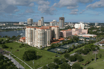
Downtown St. Petersburg is another example of high-density development that’s comfortable on a very human scale. High-rise buildings take advantage of waterfront views but large areas of open spaces with a good concentration of retail and restaurants make it very pedestrian friendly.
Planned well, high-density development also allows environmentally sensitive areas to remain in a natural state where they can continue to provide habitat for wildlife and sustainable water supplies for the region, notes Dick Eckenrod, director of the Tampa Bay Estuary Program. “We can’t continue to sprawl the way we have in the past.”
The Ultimate Sprawl?
Stretching from once-rural Hernando County to the Westshore business district, the Suncoast Expressway has been called everything from the ultimate sprawl to the most beautiful highway in the nation. Bordered by bike and walking trails, it cuts through Jay B. Starkey Wilderness Park and over the Anclote and Pithlachascotee rivers on its way to the largest employment center in the state.
“It’s a very pleasant drive but there’s no question that it tends to attract development,” Mierzejewski said. “Frankly, a lot has to do with the way local governments manage growth, particularly when it’s enabled by accessibility.”
Building new highways into undeveloped land is a tough call, says Pumariega. “The growth would have happened up there anyway, but we need to coordinate it better. We’re building models now that we hope will better manage growth by painting different scenarios and working with FDOT, the water management district and economic development groups to see what impacts growth will have at the end.”
Growth management rules as currently written probably have made sprawl worse than it might otherwise have been, adds Clifford. “Part of concurrency has really exacerbated sprawl. If you can’t build close in, you can find a piece of property further out in the suburbs where roads are still acceptable.” As future development continues, people are forced to drive further and further to get to employment centers because land-use plans often limit commercial structures. That’s beginning to change in Pasco County, where a new comprehensive land use plan specifically recognizes that problem and encourages employment centers near major transportation routes.
Higher-density residential development surrounds the employment centers to reduce the need for workers to drive to their jobs, adds John Walsh, vice president of the Pasco Economic Development Council. “We think it’s a major recruiting tool – 85,000 people commute out of the county every day and most of them would love to work in Pasco if they could.”
Beltways Being Considered
While the state government and regional transportation authority are focused on urban transit issues, Clifford says regional beltways and corridors that would open up additional land in surrounding counties are still under consideration. “At the end of the day, we need to decide what we want these roads to be – bypasses that relieve other facilities or roads to serve new growth,” Clifford said. “They’re two very distinct roads with different options on how they’re built, the land uses around them and whether they’re toll roads or not.”
But the worst-case scenario may be what’s happening today, says Tim Jackson, vice chairman of 1000 Friends of Florida. “We need a different way of thinking about moving land from rural to urban uses,” he said. “The value changes when it goes from agricultural to developed land and the public should get part of that value.”
Rather than continuing with the status quo that allows a landowner to develop the entire tract at one or two homes per acre, allowing high-density development would maximize the use of land and leave more of it open for environmental, agricultural or water uses.
“We need to find a way to accommodate growth so that the quality of life actually improves for all of us,” said Jackson, a native of Hillsborough County. “It absolutely can be done. We need to decide that some locations need to be preserved and as new people come in, we need to create additional open space and land preservations by taxing and trading with developers.”
The biggest example of that type of development is Babcock Ranch in southwest Florida where 19,000 homes will be built on a 91,000-acre ranch after the state purchased 74,000 acres for preservation. Although still controversial for extending growth further east than some local leaders prefer, the plan does allow preservation of land for panthers and other wildlife. Florida is at a crossroad, experts agree, with the success or failure of transportation systems resting squarely on land use decisions. “The critical component to getting a handle on transportation is to stop talking about linking land use and transportation and really do it,” Clifford says. “In the future, we need to think ‘this is the transportation that will be available, how many houses will it effectively serve?’ then stop building when we run out of capacity.”
Adds Mierzejewski, “Reality Check was a good thing – it made us all slow down and think about what we want to be when we grow up. Tampa could end up looking like Houston, where the best view is in the rear-view mirror, but maybe we’d be happier if we looked more like Baltimore or Denver with a vibrant central downtown area.”
[/su_tab]
[su_tab title=”Environmental Impacts”]
Air Pollution Impacts Tampa Bay Waters
Traffic congestion in Tampa Bay causes more than rising tempers for motorists stuck in miles-long jams. As other sources of contaminants are controlled, air pollution – including auto emissions – is playing an ever-increasing role in the levels of nitrogen and toxic materials deposited in Tampa Bay every day.
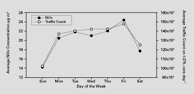
Hillsborough County’s Environmental Protection Commission tracks emissions of nitrogen oxides (NOx) in conjunction with traffic counts with both showing dramatically higher levels during the week. A total of approximately 50,000 tons of NOx is emitted annually in Hillsborough, Pinellas and Manatee counties. Using models developed by the National Oceanic and Atmospheric Administration that track atmospheric deposition and stormwater runoff, about six percent of the total nitrogen deposited in the bay comes from auto emissions.
Controlling nitrogen loadings to Tampa Bay as the region’s population grows is one of the most important challenges facing bay managers. NOx can adversely affect both the health of humans and the environment and can also produce secondary pollutants such as ozone, nitric acid and nitrate particles.
[/su_tab] [/su_tabs]
Article originally published Summer 2007.
[su_divider]