To paraphrase Charles Dickens, it is the best of places and it is the worst of places.
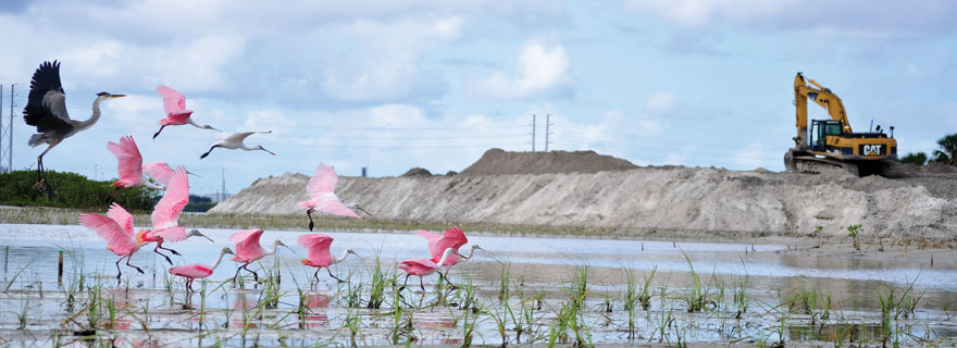
Located at the northeastern tip of Hillsborough Bay, McKay Bay is one of the most important areas for migrating birds, with wide mudflats and oyster bars surrounded by lush mangrove forests. It’s also a “hot spot” for toxic contaminants, including legacy pesticides such as DDT and chlordane that were outlawed decades ago, heavy metals and petroleum-based products that originate from one of the region’s oldest industrial areas.
Over the years, scientists have debated options for cleaning up the polluted sediments of McKay Bay. Dredging could potentially disperse them into the water column where they could spread outside McKay Bay. On the other hand, leaving them in place may impact fish and wildlife that feed on small worms, snails and shrimp in the contaminated sediments — though ongoing studies show that potentially high levels of contaminants in fish have not produced greater abnormalities when compared to fish from other parts of the bay.
“Studies conducted in 2014 show that a number of McKay Bay sediment contaminants are found within their tissues at potentially ecologically harmful levels,” said Ed Sherwood, senior scientist for the Tampa Bay Estuary Program. “In some cases, the levels exceed thresholds for both environmental and human health.”
Levels of PCBs (polychlorinated biphenyl), PAHs (polycyclic aromatic hydrocarbons) and legacy pesticides including chlordane are potentially damaging to humans who eat fish caught in the bay, noted researcher Gerold Morrison in a presentation at last year’s Bay Area Scientific Information Symposium. Scientists cannot say at this time whether mullet, crabs and other fish or shellfish caught in McKay Bay are safe to eat. More research and testing is needed to identify any real risk associated with consuming species that spend most of their life cycle in McKay Bay.
McKay now top priority for restoration
With Tampa’s urban core an increasingly popular tourist destination, restoring McKay Bay for birdwatching and other outdoor recreation has become a priority. Work actually has been underway since the late 1980s when the Southwest Florida Water Management District’s SWIM (Surface Water Improvement and Management) Program restored 38 acres. Now known as the McKay Bay Nature Trail, it features an observation tower, kayak launch and cycling trails – all practically next door to Ybor City and the bustling downtown district.
“We weren’t really looking at stormwater issues with this project – the goal then was to provide increased habitat – but we did take straight canals and turn them into tidal creeks so that the stormwater moved through a more natural system before discharging into the bay,” said SWIM’s Brandt Henningsen, who worked on the project.
More recently, SWIM and Port Tampa Bay partnered on two major environmental enhancements that won a national award from the American Association of Port Authorities in 2014. A 19-acre estuarine wetlands system was created on low-lying port property as mitigation for the port’s newest berth. The project connects freshwater marshes with mangroves and oyster reefs through a series of tidal channels. Birds flocked to the new site even before the bulldozers had left.
“Those uplands had been highly disturbed and the canals that cut through them were collecting debris and garbage from Ybor City and East Tampa,” notes Chris Cooley, the port’s director of environmental affairs. The restored site includes a 3.6-acre tidal channel and intertidal pond lined with oyster bars, 3.5 acres of mangrove habitat and 8.4 acres of saltwater marsh.
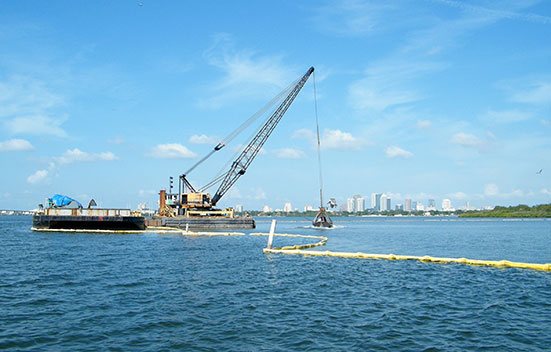
A second project at McKay Bay involved filling in a dredge hole excavated in the 1950s to create land that now houses the city of Tampa’s waste-to-energy facility and open up access to the Palm River and Tampa Bypass Canal for construction equipment.
Filling the 58.8-acre hole was the top priority in a TBEP study assessing habitat value and fish use of dredge holes across the bay. Among the conclusions:
Sediment in the 16-foot-deep hole was highly degraded because it had had apparently functioned as a sump, collecting toxics and heavy metals over the decades.
It also had very low levels of dissolved oxygen which causes extensive stress for fish and bottom-dwelling organisms like worms and shrimp.
Its location near ongoing dredge projects at Port Tampa Bay made restoration economically feasible. In fact, using the McKay Bay hole for materials from the dredging for the port’s new berth and restored uplands site resulted in significant savings compared to purchasing fill material. Additionally, the cost of hauling and disposing of the muck was reduced and space was saved on dredge disposal island for another project.
Next on the agenda is a SWIM restoration of 53 acres of land at the mouth of McKay Bay. This work will be partially supported by $500,000 from federal RESTORE Act funds associated with the Deepwater Horizon oil spill. “We’re ready to go, just waiting for the check to be signed,” notes Stephanie Powers, SWIM’s environmental scientist.
The project will include extensive habitat restoration, water quality improvements, and mitigation of erosion along the Palm River. Along with removing exotic vegetation and creating new wetlands, it will include three stormwater management areas to treat runoff from 660 acres of residential, commercial and industrial land surrounding McKay Bay.
Moving up the watershed
Other projects in the heavily industrial area bring decades-old stormwater systems up to current standards and help to capture the legacy contaminants that are still located on those sites.
One of the largest is the Florida Department of Transportation’s construction of the I-4/Selmon Expressway Connector, completed in 2014. Prior to construction, both soil and groundwater were treated for toxic material including excavating some contaminated soil and extensive treatment of ground water. Thousands of cubic yards of silt, probably containing contaminants, that had collected in the 34th Street box culvert over the decades were removed as the culvert was realigned to move water more efficiently.
“During construction, we used booms to capture contaminants from the culvert, including a lot of ‘floatables’ like plastic water bottles,” notes Bruce Hasbrouck, environmental services director for Faller, Davis & Associates, FDOT’s lead consultant on environmental compliance.
And while most of the concrete roadway is elevated, it captures rainwater that otherwise would have washed across 158 contaminated acres so that it can be treated and contaminants removed before they enter McKay Bay.
The project also includes onsite restoration of an acre of black mangroves, plus a multi-use recreational trail at the south edge of the project that extends the benefits of the nearby nature preserve for people and wildlife, Hasbrouck adds.
Moving further up the watershed, a partnership of TBEP, the Environmental Protection Commission of Hillsborough County and Pinellas County hopes to receive “Brownfields” grant funds from the U.S. Environmental Protection Agency to access potential properties for redevelopment and work with developers so they understand the benefits of remediating a site rather than moving to the suburbs. “Identifying contaminated properties and performing these assessments in advance will make redevelopment easier in the future,” said TBEP’s Sherwood.
The Ikea store just north of the Selmon Expressway has been called “the poster child” for using Brownfields funds to redevelop a contaminated site. Originally operated as a cannery from 1936 until 1981, the site required significant improvements including the removal of underground storage tanks, railroad tracks and contaminated soil, covering most of the property with two feet of clean fill dirt and signing restrictive covenants on two spots, including a retention pond. The site now contains a 353,000-square-foot store and a 350-seat restaurant that is expected to anchor a new shopping destination for the region.
“Pursuing a Brownfields grant will have direct benefits for both the bay and the surrounding communities in the future,” said Sherwood.
Published November 2016