By Victoria Parsons
It’s a common sight on the beaches bordering Tampa Bay — gently sloping sand that rises abruptly to form a bluff a few feet from the water’s edge. In almost every case, it’s a sign of rapid erosion created when waves and ship wakes wash the sand away.
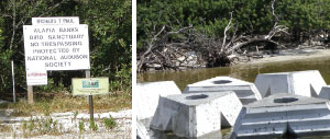
Protecting the bay’s beaches is particularly important because two of the most threatened islands also are designated as globally important bird areas by the National Audubon Society. With so much of the region’s beach already occupied by humans, the two island sanctuaries provide critical habitat for thousands of endangered or threatened birds as well as sea turtles.
And while the technology to stop erosion exists, it’s expensive and may require a trade-off with other habitat like offshore seagrass beds.
Tampa Bay’s poster child for preventing ongoing damage from erosion is Audubon’s Richard T. Paul Alafia Bank Bird Sanctuary. Created in the 1920s when the Alafia River was dredged to make it more accessible to large ships, the two islands are now recognized as one of the most important bird nesting sites in the state.
Freezes during recent winters damaged mangroves growing on the shore of Sunken Island, wiping out the first line of protection. “You can see where palm trees have just toppled over because the sand under their roots has washed away,” notes Ann Paul, regional coordinator for the Florida Audubon Society. In other locations, ancient pipes probably used when the islands were first dredged 90 years ago are exposed for the first time in decades.
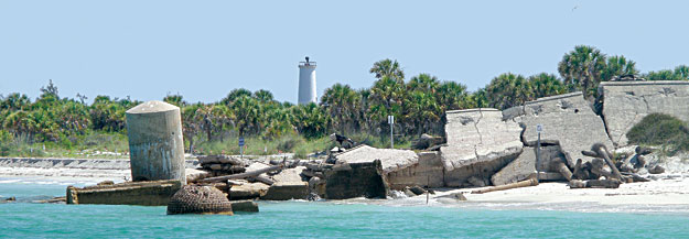
But around the corner, on the northwest shore of Bird Island, a series of concrete reef balls installed last May are slowing down the waves and protecting the shoreline. Unlike the traditional rip-rap, which only has a lifespan of five to seven years and provides very little habitat, the reef balls are designed to last for decades and provide shelter for sea creatures like crabs and small fish.
Each of the 212 balls — weighing in at more than 8,000 pounds — look like a giant Lego with a flat bottom and triangular shapes cut out of its sides. Placed offshore in a pattern that allows manatees or dolphins access to and from the shallows, the reef balls break the waves as they come ashore, then hold the sand as the water recedes.
“What we’ve done is create a calm lagoon in front of the beach,” Paul said. “We’re seeing sand accumulate instead of washing away. Mangroves and salt marsh are growing again and birds have room to nest.”
Egmont Key Still Vulnerable
Further south, at the mouth of the bay, waves and wakes from ships passing in the nearby channel continue to wash away the western shore of Egmont Key. Historic structures, including gun batteries built to defend Tampa Bay during the Spanish-American War, are now underwater. About half of the island’s land mass has been lost since it was first surveyed in 1877 and managers are concerned that it could split in half in a bad storm.
Protecting Egmont isn’t as simple as installing reef balls on a small island with clear ownership. Egmont is owned by the US Fish and Wildlife Service as a National Wildlife Refuge but that agency doesn’t have the budget or the expertise to fortify the island’s shoreline. The US Army Corps of Engineers has the expertise and the sand, but funding must come from the USFWS or directly from Congress.
The USACE already has placed nearly a million cubic yards of sand on Egmont from maintenance dredging since 2000 but without fortification the sand continues to wash away. A 2008 feasibility study by the USACE assessed alternatives and recommended the construction of a sheet pile wall. Without local funding sources, a Congressional directive is required to cover costs estimated at $15.9 million for the first year and renourishment every seven years at about $8.5 million each.
Representatives from three Congressional offices, including Rep. Kathy Castor and Senators Bill Nelson and Marco Rubio, have toured the island and Congressman Bill Young has been a long-time supporter of Egmont, notes Richard Sanchez, president of the Egmont Key Alliance.
The best hope for protecting Egmont is an unlikely source — fines paid by BP and its partners in the Deepwater Horizon oil spill. A trial is scheduled to begin later this month and some people are predicting that a final settlement could top $20 billion. Current law puts those funds into general revenue but the widely supported Restore Act would send 80% of the funds toward coastal restoration.
“After years of wear and tear culminating with last year’s oil spill, much of the Gulf Coast is in need of some major repairs. The Restore Act is one step towards revitalizing the Gulf Coast and areas like Egmont Key,” said Senator Nelson, who co-sponsored the legislation along with Senator Marco Rubio.
Without protection, the worst-case scenario for Egmont Key is nearly invisible just a few miles away. Passage Key, once a 60-acre island with a freshwater lake, has eroded so much that it is now merely a sandbar.
Oyster Bars Protect Shores, Provide Habitat
While the Alafia Sanctuary and Egmont Key highlight potential problems with habitat destruction in Tampa Bay, erosion is an issue almost everywhere that isn’t bordered by seawalls. Rebuilding oyster bars offshore is an environmentally friendly way to protect those areas, according to Peter Clark, president of Tampa Bay Watch.
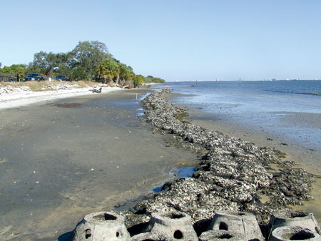
“We’ve had great successes at a number of locations in Tampa Bay,” he said. “They’re smaller, with a lower profile than some other methods, and they’re much more environmentally friendly. Not only do oyster bars help stabilize a shoreline, they create hard-bottom habitat that oysters can colonize and more oysters mean better water quality.”
Hundreds of volunteers have helped build oyster bars in Tampa Bay, one bag of oyster shells at a time in locations from Weedon Island and the Schulz Preserve to MacDill Air Force Base and the Sunshine Skyway Bridge. (Work is still underway at Schultz Preserve and Weedon Preserve, volunteer opportunities are listed in the Bay Soundingscalendar.)
At MacDill, where the southeastern tip of the Interbay peninsula is eroding rapidly, a fifth phase of oyster bars is being planned. “They’ve been very successful,” says Jason Kirkpatrick, natural resources manager with the 6th Civil Engineer Squadron. “They haven’t 100% stopped the erosion but we are seeing salt marshes growing.”
A plan to place larger reef balls further offshore is on hold following questions from the Florida Department of Environmental Protection and the Agency on Bay Management about seagrasses growing in the area where the reef balls were planned. “We took a step back and since there isn’t any money available in 2012, it’s effectively back-burnered until 2013 or 2014.”
The oyster bars, at 18-24 inches tall, are very effective most of the time, except when storm-driven waves at high tides wash over them, Kirkpatrick adds. “We’d been seeing erosion at close to a foot per year, but the oyster bars have slowed it down substancially.”
With the short-term impacts of wave-driven erosion already causing tremendous damage to some areas in Tampa Bay, the Tampa Bay Estuary Program is taking a longer look at problems likely to occur with climate change and sea level rise.
A new project focused on assessing critical coastal habitat will kick off this year, with the first meeting scheduled for Tuesday, February 28, from 9 a.m. to noon at the Tampa Bay Regional Planning Council. The long-term “on-the-ground” monitoring program would assess plant community and other functional changes in critical coastal habitats, including:
- Establishing permanent fixed transects in each of the four primary bay segments, preferably upslope from areas currently monitored for seagrass growth.
- Collecting quadrant data along the transects at low tide in November to identify plant species composition and richness, species cover, salinity and data on fauna such as fiddler crab density.
- Identifying long-term commitments fromTBEP and its partners since the monitoring program will need to continue for several decades to be effective.
Other initiatives planned to help meet the challenges of climate change include an updated habitat vulnerability assessment based on sea level rise of 0.5-2.0 meters by 2100. Additionally, an interactive tool for land-use planners is being developed based on those vulnerability maps to incorporate climate resiliency in habitat restoration and protection strategies.
[su_divider]
Originally published Winter 2012