By Marcia Biggs
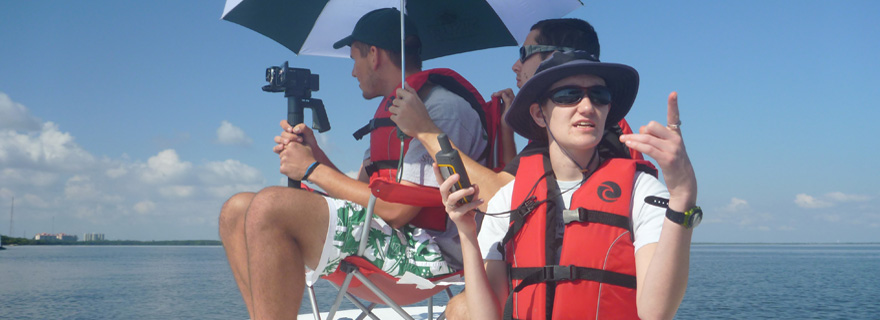
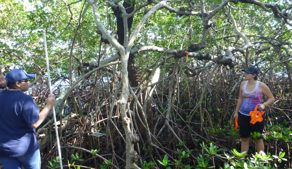
At Saint Leo University, William Ellis’s biology students are up to their knees in work – literally. Like modern-day adventurers, they slog along the Tampa Bay shoreline combating mosquitoes and scorching sun as they take GPS-enabled video and still images and record data of the mangrove forests. The lucky ones are in kayaks and canoes, while others are wading through muck and root systems as they measure and tag.
Back in the classroom, the geo-tagged imagery will be reviewed by scientists and trained student assistants to evaluate the condition of the mangrove habitat. Then it will be uploaded into a database at James Cook University in Queensland, Australia, where it will become part of the MangroveWatch global visual archive.
For the past year and a half, Ellis and Saint Leo associate professor and wetlands biologist Chris Miller have been working with a team of students, faculty, staff and alumni as part of a developing MangroveWatch program in Tampa Bay. On the other side of the globe, MangroveWatch data have been used to assess coastal erosion and mangrove loss in Vietnam, determine mangrove forest carbon storage and sea level rise risk in the Solomon Islands, and post-drought and -flood recovery in Australia.
“The Tampa Bay program is the first MangroveWatch in the Western Hemisphere,” says Ellis, whose background includes conducting marine research for the US Geological Survey. “By using satellite mapping and trained observers over the long term, the goal is to see damage and distress before it becomes destruction.”
So far, the Saint Leo team has GPS-mapped mangroves along the western shoreline of Tampa Bay from the Skyway Bridge to Safety Harbor, and along the eastern shoreline from Tampa International Airport to Port Tampa.
Why Monitor?
Mangroves occur in over 100 countries in the tropical and sub-tropical regions of the world. In many of these countries they are coming under increasing pressure from human activities such as coastal development. In an area such as Tampa Bay, which is seeking to balance urbanization with nature, the mangrove forests are essential to maintain a healthy balance to the ecosystem, says Ellis.
“Mangroves are disappearing around the world at up to 2% a year,” he says. “One of the biggest challenges in Florida will be the need to address the growing threats of coastal development and its effects on the natural habitats, including mangrove forests.
“Here in Tampa Bay, we actually have more mangroves than we did a century ago but we still need to be mindful of their degradation in addition to outright destruction. For example, the interruption of tidal flow can destroy whole forests of mangroves.” (See Bay Soundings, Winter 2014).
Mangroves in urbanized areas such as Tampa are under pressure from port and shipping activities, polluted stormwater runoff, red tide and other toxic algae, disruption of tidal flow, and wind and storm damage. However, their function in the ecosystem is vital. Research indicates that mangrove forests store up to five times more carbon than most other tropical forests around the world. Mangroves also help to reduce storm surge, purify stormwater and serve as important nursery habitat for many species of coastal life.
Public involvement
MangroveWatch in Tampa Bay has already had enormous benefits for the students at Saint Leo University, says Ellis. The most fundamental result, he says, has been a change in the perception of mangroves. The students’ increased interest has led to several studies that aid their growth as scientists and responsible citizens. For example, a third-year student is currently comparing bird counts generated from MangroveWatch video to traditional transect methods.
Ellis and Miller are taking the program public now. A presentation for the Tampa Bay Sierra Club in February brought forth a group of participants willing to adopt a segment of mangrove shoreline in Cockroach Bay. They will join Ellis and Miller for a training session later this year.
The program is looking for other groups willing to participate in the training and data gathering.
“We would like each group to select an area that might have meaning for them, perhaps as a way to do their own assessment or because of encroaching development or other threats they would like to monitor,” says Ellis.
Participants are required to go through a training session to learn how to use the video equipment – a Sony camcorder provided by Ellis. In addition, they will learn to record measurements and perform tagging on foot.
Marcia Biggs is a freelance writer living among the mangroves in Safety Harbor, FL.
Be a Mangrove Watcher
MangroveWatch relies primarily on video assessment of shoreline habitats collected by community volunteers for analysis. The Shoreline Video Assessment Method (SVAM) was specifically designed for the MangroveWatch program to enable participants to easily collect information in a standardized format. Simultaneous GPS data enables the images to be mapped to give a spatial representation of shoreline habitats and their condition. Would your group be interested in participating in the Tampa Bay MangroveWatch program? Contact William Ellis at mangrovewatchusa@saintleo.edu or call 352-588-7415 for more information.