|
The end result is a GIS database and map for decision-makers identifying all lands already acquired or slated for protection, as well as future priorities. "You begin to see a connected system that could be protected through coordinated acquisition," says Jim Beever, supervisor of Florida Fish and Wildlife Conservation Commission's Southwest Regional Office of Environmental Services, "not just along greenway corridors but also between them." Small coastal parcels are the first priority since these lands are the first to be snatched up by developers.
"Now when a county commissioner asks what's needed and how much it will cost, we can respond with an intelligent, well thought-through answer that transcends geo-political borders to help preserve and protect wild animals in decline," adds Beever. The plan also extends beyond habitat boundaries from bay to riverine to uplands and inlands.
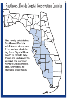
The effort so impressed project funders at the U.S. Fish and Wildlife Service that they intend to expand the corridor north to Apalachicola and, ultimately, to Florida's east coast.
Agency partners contributing to the development of the Southwest Florida Coastal Conservation Corridor Plan include The Nature Conservancy, Florida Fish and Wildlife Conservation Commission, Florida Department of Environmental Protection, Agency on Bay Management, and the U.S. Fish and Wildlife Service, along with 21 counties, three water management districts and three national estuary programs.
Beever notes the exceptional contributions of several individuals and partners, especially GIS coordinator Mary Bryant of The Nature Conservancy, Suzanne Cooper of the Tampa Bay Regional Planning Council, Mercily Toledo and Ken Huntington of the Florida Department of Environmental Protection, and Holly Greening of the Tampa Bay Estuary Program.
The GIS database and plan will be posted on The Nature Conservancy website in the spring of 2004 (go to Florida chapter at www.nature.org).
Parties may request notification by emailing mbryant@tnc.org.
|