 |
||||||||


Tampa Bay Research Now National Model for Ecosystem Interactions
A decade-long study on Tampa Bay's ecosystem has become a national model for integrating research on the complex interactions of biological, chemical, geological and hydrological factors in estuaries.
The U.S. Geological Survey, working with the Tampa Bay Estuary Program, will publish a synthesis of the research, covering the complex interactions of biological, chemical, and geological systems. interactions in November. Entitled "Integrating Science and Resource Management in Tampa Bay, Florida," the research looks at how ecosystems function as a whole.
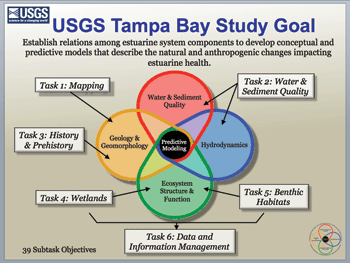
"This is a huge cultural shift at USGS," notes Dr. Kimberly Yates, the biogeochemist directing the study. "To effectively manage ecosystems, we need to know how they work together."
The $20 million project involved scientists at 24 organizations including Tampa Bay Estuary Program, the University of South Florida, Eckerd College, the Florida Fish and Wildlife Research Institute, National Oceanic and Atmospheric Administration, Southwest Florida Water Management District and Mote Marine Lab.
"Tampa Bay's CCMP (Comprehensive Conservation and Management Plan) is a national model for integrating scientific research and management actions," she adds.
Among the most interesting findings:
- Tampa Bay was actually formed as a series of collapsed sinkholes, not a submerged river bed, as some scientists had theorized. More than 100 sediment cores show the land underneath Tampa Bay changing from forest to marsh about 7,000 years ago. The transition was extremely rapid, occurring over a period of about 50 years.
- Even today, the coastline is a "leaky sponge" discharging fresh groundwater into the bay. Those discharges are likely to be a significant source of nutrients in bay waters.
- A dynamic urban growth model, which tracks the relations between thermal changes, impervious surfaces and seagrass growth, shows that seagrass acreage declined in Tampa Bay as the region's impervious surfaces increased, until about 1985 when the trend reversed.
- A topobathic map of Tampa Bay that combines data on both land and seafloor elevations in an easy-to-use document was the first seamless format developed (see Bay Soundings Spring 2011 for more information.) Those techniques are now being used nationwide to help scientists understand complex processes in ecosystems.
The Tampa Bay project also focused on data management and information and a highly interactive website designed to facilitate the exchange of scientific information – including public outreach to involve citizens in the decision-making process.
For more information, visit http://gulfsci.usgs.gov/tampabay/index.html.