 |
||||||||
Agency on Bay Management Releases
State of Tampa Bay Reports
 Audubon Coastal Islands Sanctuaries Program Protects Tampa Bay Bird Colonies
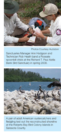
By Ann Hodgson
Audubon of Florida’s Florida Coastal Islands Sanctuaries Program dates back to 1934, when Fred Schultz was hired as the first Audubon warden to protect nesting colonial waterbirds in Hillsborough Bay at the historic Green Key Bird Sanctuary. Over the next 75 years, the sanctuaries program expanded to protect other colonies with the help of public and private partners. Annually, the program surveys over 100 colonies supporting 50,000 nesting pairs and 30 species, and staff provides comprehensive protection for over 90% of the regional waterbird population. We post, manage and patrol 28 sanctuary islands, which support over 20,000 pairs of colonial waterbirds, or 40% of the regional population.
Waterbird Habitat Restoration and Management
Since most colonial waterbirds roost on bay islands, habitat management increases the likelihood of successful nesting. Working with other land managers, we actively work to restore habitat and protect colonies throughout the bay. Recent projects include:
- Management of Manbirtee Key, a spoil island at Port Manatee, through a 20-year agreement with the port authority. This island supports ground-nesting least terns (a threatened species), and Wilson’s plovers (a “WatchList” species). Least terns nested on the island the first year after it was completed, and the colony has grown annually.
- As a lead participant on the Tampa Port Authority’s Migratory Bird Protection Committee, we worked with the authority and WRS, Inc. to design a protective breakwater, installed in early March 2007, to protect beach-nesting American oystercatchers (a species of special concern) that nest on the shores of Spoil Island 2D.
- Jointly with Tampa Bay Watch, we organize and recruit volunteers for annual Monofilament CleanUP! events at more than 50 islands and shorelines in October, when birds are not nesting, to protect birds from death due to entanglement.
- With Sarasota County and the Sarasota Bay National Estuary Program, we planned a wave-break to save the Roberts Bay Bird Colony Islands – the most important bird sanctuary in Sarasota Bay. The work was conducted over the winter of 2007-08. A pair of American oystercatchers, attracted to the sandy shore behind the new wavebreak, fledged a chick in Spring 2008.
To support regional conservation, we also participate in many cooperative planning efforts aimed at improving management of the bay’s bird populations, including:
- Hillsborough Bay conservation efforts, responsible for protecting roughly 20% of the oystercatchers nesting in Florida
- U.S. Fish & Wildlife Service Wood Stork Conservation Team, surveying and protecting regional stork colonies and promoting national conservation goals for this federally listed endangered species
- Snowy Plover Working Group, to improve conservation for this threatened species
- Florida Fish and Wildlife Conservation Commission’s Seagrass Prop-scarring Stakeholders Working Group, to protect seagrass meadows that produce the forage fish waterbirds depend on in Tampa Bay.
To increase law enforcement protection for the region’s birds, we organized Marine Unit Interagency Workshops in Dunedin, Vero Beach and Ft. Myers. The workshops, attended by 200 officers and resource managers representing 50 agencies, led to increased cooperation of marine officers in wildlife and habitat protection.
Since 2003, we have conducted roseate spoonbill population studies to determine annual population productivity and distribution in the Tampa Bay area. Over the past five years, 850 nestling spoonbills were banded at two colonies. Re-sightings from south Georgia and throughout central Florida are increasing basic knowledge of this rare species of special concern.
Sanctuaries staff also provide support for local Audubon ColonyWatch teams, and recommended changes to the management plan for Shell Key Preserve to better protect its nesting bird populations.
For more information, contact Dr. Ann Hodgson at 813-623-6826 or email ahodgson@audubon.org.
Pinellas County Water and Land Management Report
The Pinellas County Department of Environmental Management (DEM) has long played a role in supporting, planning and implementing efforts to improve the quality of water in Tampa Bay and its surrounding habitat. Two DEM divisions – Watershed Management and Environmental Lands – are engaged in key projects and ongoing programs.
Watershed Management Division
Among the division’s responsibilities is the assessment of the quality of surface waters within Pinellas County including Tampa Bay. Additionally, the division develops and implements watershed plans for the county’s major drainage subbasins, many of which discharge to Tampa Bay. Several of the division’s ongoing programs are noted below. Questions or comments can be directed to Kelli Levy, Watershed Management Division director (klevy@pinellascounty.org).
Water Quality Monitoring - Pinellas County began monitoring and reporting on water quality within Gulf Coast waters, Tampa Bay, Lake Tarpon, Lake Seminole, and priority streams and creeks in 1991. Program changes in 2002 allowed the county to provide improved and more detailed assessments of water quality, seasonal variations and pollutant loadings. For more information on the Pinellas County water quality monitoring program contact the Watershed Management Division at watershed@pinellascounty.org or visit www.pinellascounty.org/environment.
Watershed Planning and Implementation - Pinellas County has completed three comprehensive watershed plans and has seven projects planned or in progress. Plans have been completed for Allen’s Creek, Lake Tarpon and Lake Seminole. The seven ongoing or planned projects include: Brooker Creek, Roosevelt Creek, Cross Bayou, Starkey Basin, Hollin Creek, Lake Tarpon Outfall Canal, and the Northwest Pinellas Resource Protection Plan. Watershed plans provide guidance for projects to correct flooding issues and to enhance and restore water quality and natural systems. Improvements recommended by the plans serve as the basis for developing the surface water capital improvement program funded by the Penny for Pinellas. For more information on the watershed planning and implementation program contact the Watershed Management Division at watershed@pinellascounty.org or visit www.pinellascounty.org/environment.
Protecting Lake Tarpon - Called the jewel of Pinellas County, Lake Tarpon is the county’s largest lake with a surface area of four square miles. Ringed by cypress trees and known for its highly tannic water, Lake Tarpon is popular with anglers, boaters, water skiers and jet skiers. Unfortunately, over the past two decades Lake Tarpon’s water quality has been declining as excess nutrients run into the lake from a 52-square-mile watershed. To address the lake’s water quality issues, the Lake Tarpon Drainage Basin plan was developed in 1998. The document provided an assessmentof the lake condition, lake improvement and protection goals, and recommended projects to meet these goals. Currently, the county has scheduled three projects to treat stormwater discharging to Lake Tarpon. The projects include the use of alum or aluminum sulfate, a common drinking water treatment chemical. Alum binds to nutrients and settles them out of the water column leaving only clean water to enter the lake.
Together, these projects will prevent thousands of pounds of pollutants from entering the lake, but they remain only a small piece of the puzzle. Continued improvements will require action by homeowners living in the watershed to reduce nutrient pollution from fertilizers and other sources. For more information, contact the Watershed Management Division at watershed@pinellascounty.org or visit www.pinellascounty.org/LakeTarpon.
Environmental Lands Division
Pinellas County’s Environmental Lands Division is the management authority for 15,500 acres of wild lands and waterways scattered throughout the county. Collectively called environmental lands, these protected parcels are separated into preserves (each with an approved comprehensive management plan) and management areas. Over the past 30 years, Pinellas County has purchased and protected ecologically sensitive areas ranging in size from 8 to 8,000 acres. Each of these open space “gems” are important for their biodiversity. Altogether, environmental lands constitute 8% of the county’s geography.
In Florida’s most densely populated county, the Environmental Lands Division has developed an award-winning model of urban ecology that includes staff development, volunteerism, law enforcement and interagency cooperation. Its programs include species inventories, ecological monitoring, prescribed burns, environmental education and interpretation (including outreach), and ecological restoration.
Recent restoration projects are highlighted below. Questions and comments can be directed to H. Bruce Rinker, division director, at brinker@pinellascounty.org or by calling 727-453-6912.
Mobbly Bayou Preserve - Located at the northern end of Upper Tampa Bay, this 396-acre preserve encompasses a wide diversity of natural communities, though many areas have suffered environmental distress. Approximately 200 acres have been identified for restoration and enhancement with funding from Pinellas County, Southwest Florida Water Management District, and the City of Oldsmar. The goals are to restore the hydrology of the bayou’s tidal creek system and to enhance the degraded wetland and upland communities by removing exotic species and planting native species.
Allen’s Creek Management Area - This 33-acre parcel is bisected by Belcher Road in Largo. The eastern parcel was restored in 2005 through cooperative efforts with Pinellas County, Southwest Florida Water Management District’s Surface Water Improvement and Management program, and the City of Largo. This project restored and created freshwater and estuarine wetlands, and enhanced associated upland habitats. This resulted in a low-salinity fish nursery habitat and improved the quality of the water entering Tampa Bay from this highly urbanized watershed. Within days of completion, manatees browsed the shallows and flocks of wading birds investigated the shoreline.
Alligator Lake Management Area - Located near Safety Harbor, this 53-acre area is connected to Old Tampa Bay. Once tidally influenced, the creek system was dredged and filled to create the lake. A restoration project is being conducted to benefit wading birds by providing additional nesting, roosting and forage areas. This project will replace low-quality and exotic-dominated areas with expanded marshes, mixed wetland forests and pine flatwoods. By improving drainage ditches and associated wetlands, the quality of stormwater entering the lake will be enhanced.
Tampa Bay Meeting Water Quality Targets
For the second year in a row in 2007, all four major bay segments of Tampa Bay (Old Tampa Bay, Hillsborough Bay, Middle Tampa Bay and Lower Tampa Bay) had sufficient water quality to promote the natural recovery of underwater seagrasses. Seagrasses are critical to the bay’s ecosystem and serve as the “canary in the coal mine” for evaluating the effects of nutrient pollution to the bay. With improvements in wastewater and stormwater treatment, and checks on dredging and filling activities, Tampa Bay has regained 6,000 acres of seagrasses since 1982. The bay now supports 28,299 acres of seagrass – far less than the Tampa Bay Estuary Program’s goal of 38,000 acres, but the highest recorded total since the 1950s.
To help track progress in attaining seagrass recovery, the Tampa Bay Estuary Program annually compares water quality to established targets in the bay and reports the results in a form called the “Decision Matrix.” This simple chart uses a red, yellow and green color system (similar to a stoplight) to assess overall water quality in the bay relative to conditions that would be appropriate for the natural recovery of seagrass in each major bay segment. The rating system considers both the amount of microscopic algae (as indicated by chlorophyll a, a plant pigment) in the water, as well as the amount of visible sunlight penetrating the water column. Both measures are used to evaluate whether enough light was available to seagrass over the past year to further promote seagrass recovery in the bay.
The water quality results for 2007 reinforce the notion that continuing efforts to manage nitrogen loads to the bay have had significant environmental results. Sustaining this progress despite an expected doubling of the population in Tampa Bay by 2050 will be the challenge for managers in the future.
For more information, contact Ed Sherwood at esherwood@tbep.org.
Hillsborough River Plan Targets Bacterial Pollution
By Holly Greening
The Florida Department of Environmental Protection is working with the Tampa Bay Estuary Program and engineering firms HSW and PBS&J to assist local governments and stakeholders in developing a comprehensive Basin Management Action Plan (BMAP) to identify and address the causes of bacterial water pollution in the Hillsborough River. The estuary program is providing facilitation and support services at the request of Hillsborough County and the City of Tampa. Development of the BMAP was initiated in 2006, and is expected to be finalized by the end of 2008. A draft plan was delivered to the Florida Department of Environmental Protection (FDEP) in June 2007.
Florida requires that all local governments with waterways that have been designated as “impaired” develop BMAPs to reduce loadings of key pollutants such as nutrients, bacteria and mercury. The BMAPs will spell out specific strategies to ensure that levels of these pollutants do not exceed the Total Maximum Daily Loads established by the state for those waterways. Waterways may be designated impaired for one or more pollutants. The BMAPs will provide a watershed-based approach to restoring these waterways to health.
In Hillsborough County, 77 water bodies are considered impaired because of excess nutrients, low oxygen, heavy metal contamination or other problems. The Hillsborough River BMAP will address bacterial contamination (fecal coliform) in six segments of the river’s watershed.
The BMAP approach involved a review of existing water quality information; an inventory of existing or planned pollution-control projects; identification of issues and information gaps; and development and implementation of comprehensive action plans to address pollution sources. Stakeholders involved in the process include the Environmental Protection Commission of Hillsborough; city and county public works, planning and water departments; health departments; the Southwest Florida Water Management District; private industries; scientists and citizens.
A series of stakeholder meetings were held to identify strategies for reducing bacterial loadings in the Hillsborough River watershed. The draft plan calls for installation of auxiliary battery-powered generators at city sanitary sewer pump stations to prevent sewer overflows during power outages; comprehensive, integrated stormwater treatment planning and implementation; and increased public education to promote the proper disposal of pet waste.
FDEP also sponsored a microbial source tracking program conducted by USF and PBS&J to help assess the specific causes of bacterial contamination in different portions of the river. Results indicate a variety of human, cow and deer, and other wildlife sources. These results will be coupled with a decision support tool developed by Terra Ceia Consulting to provide a framework for prioritizing waterbodies and specific locations for follow-up management actions.
For more information, contact Holly Greening at 727-893-2765 or email hgreening@tbep.org.
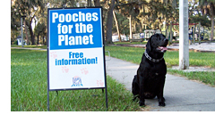 “Pooches for the Planet” Campaign
 Against Pet Waste
The Tampa Bay Estuary Program is using the “pictures don’t lie” approach to educate residents about the harmful water quality impacts of pet waste.
During a recent pilot project in a Tampa neighborhood bordering the Hillsborough River, TBEP developed a poster that showed the location of waste piles left in the park. This GIS map was a key component of a social marketing campaign that featured a monthly pet waste information station set up in the park. The station offered TBEP staffers an opportunity to conduct surveys of dog owners, find out what they knew about the link between dog waste and water quality, and encourage proper disposal of pet waste by giving away free products such as refrigerator magnets with the “Pooches for the Planet” message and fire hydrant-shaped bag dispensers that can be attached to a dog’s leash.
The “Pooches for the Planet” campaign seems to have paid off; at the end of the 8-month pilot project, the number of waste piles in the park decreased by 48%! TBEP now hopes to build on this success by providing informational doorhangers, magnets and signs to other neighborhoods, as well as to pet supply shops, veterinary offices, and animal adoption shelters. Other organizations, including Keep Hillsborough Beautiful, Hillsborough County’s Adopt A Pond Program, Keep Manatee Beautiful and the Pinellas County Parks Department have joined the effort by initiating their own pet waste education campaigns in the bay watershed.
TBEP initiated the “Pooches for the Planet” project out of concern about high fecal coliform levels in a number of bay tributaries. Pet waste has been implicated as a potential source of bacterial contamination in many of these areas, and may be responsible for as much as 95% of the fecal coliform found in urban stormwater nationwide.
For more information, contact Nanette O’Hara at nanette@tbep.org.
Tampa Bay Aquatic Preserves
By Randy J. Runnels
The Tampa Bay Aquatic Preserves (TBAP) program is administered under FDEP’s Office of Coastal & Aquatic Managed Areas. The local program manages four areas of submerged land that have been designated by the state legislature for special protection as aquatic preserves. These include the Terra Ceia Aquatic Preserve in Manatee County, the Cockroach Bay Aquatic Preserve in Hillsborough County, and the Pinellas County Aquatic Preserve and Boca Ciega Bay Aquatic Preserve in Pinellas County. State-owned islands are also part of the preserves in most of these areas.
Within the boundaries of the preserves TBAP staff identify and track environmental issues, participate in regulatory, review, and conduct education and outreach activities. Identifying and addressing issues involves the input and assistance of stakeholders and scientists. Regulatory review focuses on smaller impacts like individual docks as well as large dredging and infrastructure development projects. The program is active in interpreting the results of research to inform the public of the importance of, and approaches to resource protection.
Research Support
As the five-year USGS Tampa Bay Study has drawn to a close, the TBAP program has begun to shift attention to a proposed five-year EPA study. Continuity between the projects is important to ensure that planned research builds upon existing information. TBAP continues to give support to the experimental design and field logistics of a variety of ongoing research projects.
The field work for a collaborative research project between TBAP and Eckerd College is drawing to a close. This work is investigating the role of physical factors in the distribution of plants on islands around Tampa Bay. Results of this work will be directly applicable to ongoing island habitat enhancement.
Regulatory Review
In addition to review of smaller proposed projects, TBAP staff have been providing input on a number of large proposals. The program has a long history of reviewing linear infrastructure development, and this experience is being applied to the Gulfstream Bartow lateral pipeline extension, the Port Dolphin LNG terminal project and the Tampa channel widening proposal. These projects are outside preserve boundaries, but they indirectly affect preserve resources.
Resource Management
In addition to collaboration on other projects, TBAP has a number of ongoing habitat restoration and enhancement projects. These include island vegetation restoration, shoreline stabilization and other initiatives. By working closely with regulatory staff, TBAP staff are directing mitigation and public interest requirements toward worthwhile preserves projects. A project database and a system for tracking these projects have been established.
TBAP has one operating real-time water quality station in the Frog Creek system, and another station at the mouth of Bishop Harbor is nearing completion. These stations are designed to send data on multiple parameters to the internet via radio telemetry. This information is handled through a partnership with USF, and it is available online. A link to the Frog Creek site can be found at the Terra Ceia Aquatic Preserve web page at www.dep.state.fl.us/coastal/sites/terraceia/.
Education and Outreach
TBAP has a number of initiatives intended to reach out to stakeholders. Participation in proactive programs like the Clean Boating Partnership is a high priority. Displays at community events, boat shows and environmental education events are used to showcase program identity and activities to the public and to potential collaborators. Preserves staff routinely do invited talks for civic organizations and other groups.
Education is often achieved through volunteer involvement. Students enrolled in service courses at Eckerd College have teamed up with members of the Association of Senior Professionals at Eckerd College (ASPEC) to rebuild interpretive trails. Ohio State University Students spent an “alternative spring break” helping TBAP staff replace invasive exotic plants with native plants on islands. A number of individuals and organizations enhance the program’s capacity to do projects like these.
“Big Picture” Initiatives
TBAP often participates in larger collaborative efforts intended to benefit the Gulf of Mexico and the global ocean ecosystem. For four years, TBAP has collaborated with other gulf states, Mexican states and Caribbean nations on the Gulf of Mexico Alliance to work toward the management of the Gulf of Mexico as one ecosystem. Recently the Chinese State Oceanic Administration invited the TBAP manager to south China to review conservation strategies associated with a UN initiative. That visit also provided a unique opportunity to present the Gulf of Mexico Alliance as a model for similar collaboration between China and Vietnam in the Gulf of Tonkin. Because Tampa Bay is a microcosm of Florida’s coastal issues, advice often is sought from TBAP staff by other programs around Florida and beyond.
Fresh Water Restores Life on the Hillsborough River
By Phil Compton
Tidal rivers, where fresh water gradually mixes with incoming tides, are among the most fertile place on Earth. Since the early 1970s, one of Tampa Bay’s most important nurseries, the Lower Hillsborough River, had been deprived of a daily flow of its own fresh water for hundreds of days each year, with devastating effects on life in the river and bay. This year, beginning New Year’s Eve 2007, life is being re-born in the river as five million gallons of water per day is released over the dam at Rowlett Park.
In February 2000, Friends of the River was formed to appeal the Southwest Florida Water Management District’s initial minimum flow rule for the Lower Hillsborough River. The rule would have forever prevented the lower river from receiving water most of each year, instead relying on re-routing 6.5 million gallons of Sulphur Springs’ water that naturally flowed into the river downstream.
Friends of the River settled its appeal with the district by agreeing that further study would determine the river’s daily water needs in dry periods to maintain its ability to nurture and maintain life. After years of research, the district’s new data showed that in addition to water from Sulphur Springs, the river needs 13 million gallons a day of fresh water and 16 million gallons during the spring when fish swim upriver to spawn. Increased water releases over the next five years are expected to meet 97% of the lower river’s recovery needs, with the balance provided in the following five-year period. Progress will be reevaluated every five years beginning in 2012.
The Friends’ eight-year public education campaign was essential in building awareness and support for the river’s recovery. The group is now working with the community to help restore a more natural shoreline that will provide habitat for wildlife and filter stormwater pollution at its source from hundreds of private backyards lining the riverbank.
For more information, contact Phil Compton at 813-841-3601 or phil.compton@sierraclub.org.