In 1905, when Teddy Roosevelt named Passage Key one of the first National Wildlife Refuges, it was a lush island with a freshwater lake that provided critical habitat for more than 100 species of birds. Today, all that remains is a sandbar near the mouth of Tampa Bay.
While it’s not likely that the nearby Egmont Key will totally wash away, bay managers are watching the western edge of the island move inland at a rapid pace. “There is almost no high elevation in the center of the island which would prevent a serious storm from causing a breech, just like Johns Pass,” notes Jim Spangler, past president of the not-for-profit organization Egmont Key Alliance.
“Egmont Key is in greater jeopardy than it ever has been,” he said.
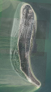
The problem is the natural movement of sand, perhaps but not definitely made worse by the wakes of large ships steaming into ports that border the bay. Currents moving in and out of the bay sweep past the island, carrying sand from the more developed north and western segments to create a sandbar tail at the southern tip. Once wide beaches on the western shore now end abruptly at three-foot cliffs, making it difficult if not impossible for loggerhead turtles to lay their eggs on the island. Historic structures, including gun batteries built to defend Tampa Bay before the Spanish-American War, are sinking underwater at a quickening pace.
Saving the island to preserve its wildlife habitat and cultural resources will require that multiple government agencies work together to replace the sand before it totally washes away. Congressional involvement is imperative because no single state or federal agency has the authority or funding to save the island.
The Agency on Bay Management voted unanimously in January to formally request that U.S. Representative Kathy Castor assist in obtaining funding to protect the island, which is in her congressional district.
In the past, with support from U.S. Rep. Sam Gibbons, the U.S. Army Corps of Engineers has received additional funds for Egmont Key. Sand collected from its operations and maintenance dredging activities can be placed at beneficial use sites but only if it is at the least cost to the project, including 300,000 cubic yards in 2000 and another 700,000 cubic yards in 2006. Shore protection projects require a separate feasibility study for erosion control. The ACOE completed an study at Egmont in 2008 but it did not meet the required cost:benefit ratio.
ACOE is finalizing plans for a major expansion of the Tampa Harbor channel (see related story) along with an update on its dredged materials disposal plan last reviewed in 2002. Most dredged material from upper Tampa Bay is placed on islands maintained by the Port of Tampa. Material from lower Tampa Bay is typically deposited at an offshore site where capacity is virtually unlimited.
Costs, including necessary permits, are typically more expensive for beneficial uses like restoring the beach at Egmont Key. Other projects, like filling a dredge hole in McKay Bay near MacDill Air Force Base, are being considered by the Tampa Bay Dredging Advisory Group. The Southwest Florida Water Management District’s Hillsborough River Basin Board has budgeted $2.5 million to help cover additional costs for that project.
long with increased costs for transporting dredged materials, the Florida Department of Environmental Protection’s “Sand Rule” requires that sand placed on shorelines contain less than 5% silt. Sandy sediment derived from the maintenance of coastal navigation channels may contain up to 10% silt, and sediments between 10% and 20% silt content are considered suitable for nearshore placement. That means that much of the dredged material from Tampa Bay – particularly the material from ongoing dredging required to maintain appropriate depths in channels – cannot be used in beach restoration projects.
“The FDEP has expressed concerns that too much silt results in higher turbidity,” explains Aubree Hershorin, ACOE biologist. Underwater, excess silt floats away in currents and may smother benthic creatures. On beaches, it can make sand so compacted that it’s difficult for sea turtles to dig holes for their eggs.
Two projects scheduled for construction later this year are expected to generate approximately 45,000 cubic yards of material from channels in Manatee County, including two near Longboat Key and two near the Sunshine Skyway Bridge. Dredged material from those projects are expected to meet FDEP standards for placement and will be placed just off the Egmont shore in the hopes that wave action carries some of the sand to the beach where it is needed.
Even as the western shore of Egmont continues to wash away, 97 acres set aside as a wildlife sanctuary are thriving. Joint efforts by the US Fish and Wildlife Service, Florida’s Fish and Wildlife Conservation Commission and volunteers through the Egmont Key Alliance have helped it become important habitat for 117 species of shorebirds including nesting sites for brown pelicans, royal, sandwich and least terns, laughing gulls, black skimmers and oystercatchers. It also is home to a large population of gopher tortoises, which is particularly important because the island’s location isolates them from bacterial infections that threaten other colonies.
And as the search for money to save Egmont Key continues, the Fish and Wildlife Service plan for Passage Key also brings a ray of hope for the small island that once hosted thousands of nesting birds. “There is some talk of renourishing Passage Key,” notes Gisela Chapa, refuge manager. No funds, however, have been budgeted or requested.
Corps Finalizing Plans for Wider Ship Channel
After reviewing a long list of alternatives for federal channels in Tampa Bay, the U.S. Army Corps of Engineers has completed a draft report recommending that widening cuts A and B is the most cost-effective option for expansion.
The review began in 2001 when the “fantasy-class” cruise ships began calling at the Port of Tampa. The extra-large ships — 855 feet long and 125 feet wide with a draft of 27 feet – require such large safety zones that no ship can pass them in the channel. ACOE plans call for widening Cut B just north of the Sunshine Skyway Bridge from 500 to 600 feet first and then widening Cut A north of the Sunshine Skyway bridge using “lessons learned” with the first expansion. Construction is tentatively scheduled for 2013.
All of the dredged material is expected to go to the offshore disposal site except for rock materials that may be placed on a nearby site in Tampa Bay to mitigate for the loss of hard-bottom habitat when the channel is widened. Ironically, some of the bay’s best hard bottom was apparently created when the original channel was dug in the 1970s. To minimize impact on existing hard bottom, the 100-foot addition will be dug only on the north side of the channel instead of the original plan to widen the channel 50 feet on both sides.
[su_divider]Originally published Winter 2011